Toucan Play That Game

July 09, 2019 By: Juanita Jean Herownself Category: Uncategorized

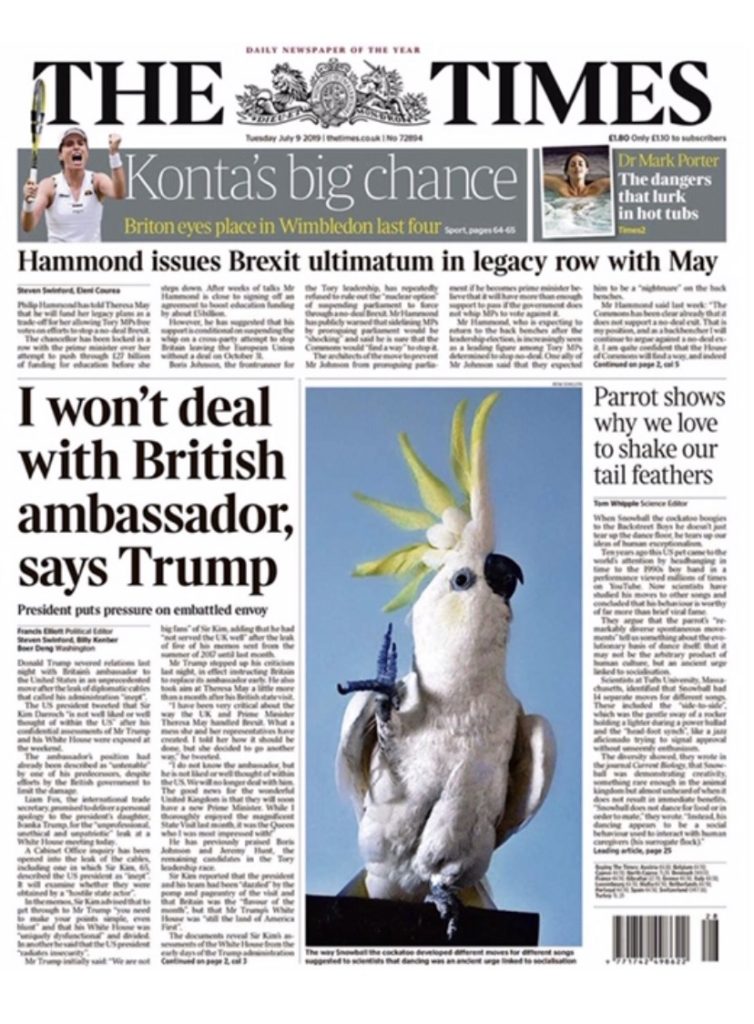
Just coincidence? Is London giving Trump the bird?

I do not know who the editor of the Times of London is, but they deserve a raise.


Thanks to Deb for the heads up.

Be social and share!

0 Comments to “Toucan Play That Game”


  1. In the news biz timing is everything, and a picture is worth, oh you know…

    1
  2. Sandridge says:

    Those Brits can be subtle.

    OT: For those of you [or F&F] living from East Texas [incl Houston], Louisiana, New Orleans area, Arkansas, Mobile, and inland to at least the Ohio, Missouri, Mississippi Valleys:

    Potential tropical cyclone ‘Invest 92L’ [if named will be Barry] is gradually getting better defined by the weather models used to predict TS’s and hurricanes.
    This developing system is looking like it will indeed move offshore of the W/NW Florida coast, go south some distance into the Gulf of Mexico, rapidly intensify, and then move west along the northern Gulf Coast.
    The models currently have it then curving in and making landfall this weekend, in SW delta Louisiana and traveling roughly up the Mississippi Valley over or slightly west of New Orleans. It then moves N/NE into the inland states mentioned.

    92L/Barry is expected to be no more than a Cat 2 storm at most, BUT, it is forecast to carry a tremendous amount of precipitation.
    The Mississippi River in LA, and most other mid-south and mid-west rivers are currently in flood-stage conditions.
    A rain-heavy tropical system traversing over these river’s basins has the potential to be a major disaster.
    The WXnut chatter is that a direct hit on NOLA could destroy it, given it’s already near-flood river stage. I won’t go into all the details, look it up from some reliable sources [your teevee weather people are usually ‘slow’ on this stuff].

    2
  3. Sandridge says:

    Official NOAA NHC forecast:

    https://www.nhc.noaa.gov/text/refresh/MIATWDAT+shtml/091816_MIATWDAT.shtml?

    000
    AXNT20 KNHC 092333
    TWDAT

    Tropical Weather Discussion
    NWS National Hurricane Center Miami FL
    733 PM EDT Tue Jul 9 2019

    Tropical Weather Discussion for North America, Central America Gulf of Mexico, Caribbean Sea, northern sections of South America, and Atlantic Ocean to the African coast from the Equator to 32N. The following information is based on satellite imagery, weather observations, radar and meteorological analysis.

    Based on 1800 UTC surface analysis and satellite imagery through
    2310 UTC.

    …SPECIAL FEATURES…

    A broad 1011 mb low pressure area centered near Apalachicola Florida will move out over the northeastern Gulf of Mexico tonight. This system has a high chance of becoming a tropical cyclone during the next 48 hours as it moves westward across the northern Gulf of Mexico. Heavy rain is likely during the next several days from the Florida Panhandle to the Upper Texas coast.
    This system could produce wind and storm surge impacts later this week or this weekend from Louisiana to the Upper Texas coast, and Hurricane and Storm Surge Watches could be required for a portion of the northern Gulf Coast on Wednesday. High seas and very gusty squalls are expected across the northern Gulf of Mexico during the next several days. For more information, please see products issued by your local weather forecast office and the NOAA Weather Prediction Center.

    3
  4. Mary O'Grady says:

    The “Times” is owned by Rupert Murdoch. This picture placement therefore surprises me.

    4
  5. Mary O’Grady:
    I used to think that way too, until my brother-in-law who’s been in the industry pointed out that Murdoch is only in it for the money. Roger Ailes was the true believer.
    The London Times sells copy to Britains, who I don’t think are fond of Trump.

    5
  6. Sandridge says:

    Weather heads-up again, some very recent, very knowledgeable comments made about what the WX models are forecasting. A complex analysis simplified.
    That Cat 2-3 into Galveston outlook is downright scary:

    1. “GFS now similar to the 18z Euro. Makes a pretty sharp turn NNE.
    Western New Orleans metro gets 18-20″on this run.” [18-20″ of rain there would be a very major event]

    2. “New UKMET has a Cat 2/3 hurricane striking directly into Galveston Bay, TX.”
    [Hard to imagine, then where does it go? Houston…]

    It’s Wednesday, landfall is progged for Sat/Sun. They’re only models, but usually pretty good, although this is a weird system.
    People need to be starting ‘a plan’ now.
    OK with me so far, just don’t want it 100-150 miles to the west on my head.

    https://www.nhc.noaa.gov/news/key_messages.png?201907100533

    https://www.nhc.noaa.gov/

    6
  7. Everything happens for a reason, right? On any other day that bird would be on page 40.

    7
  8. Joe Hill says:

    I assume we even HAVE a FEMA director, or did Trump fire him/her and not replace them?

    8
  9. Wow! That yellow stuff erupting from his head – it does bear a resemblance to the Golden Gibbons yellow stuff erupting from his head!

    Thanks for the weather alert. After it hits down there, it is estimated that the remains will hit the Appalachian Trail and dump on us. We had a helluva rainstorm just the other day. You may have heard about or even seen pictures. The guy in the pink shirt is now world famous.

    9
  10. Sandridge says:

    maggie, That major storm and flooding event in the mid-Atlantic/DC area was actually related to the origins of this developing tropical cyclone starting ~last Friday. 92L started as an intense low trough stretching from MO, KY, TN, enhancing your rains, which drifted S/SSE and went offshore of the FL panhandle, and is now further intensifying over the very warm Gulf waters.
    In short, it likely will become a hurricane [Barry] by Friday, make landfall in LA and/or TX Sat/Sun, then progress N/NE/E, right back at you in a giant week long loop.

    I can’t keep up with all the WXnut chatter [and I are one], so I’ll just pick out a few sentences from the latest official NHC Forecast Discussion #1, on what is now called “Potential Tropical Cyclone Two”, Invest 92L:

    https://www.nhc.noaa.gov/text/refresh/MIATCDAT2+shtml/101457.shtml

    “WTNT42 KNHC 101457
    TCDAT2

    Potential Tropical Cyclone Two Discussion Number 1
    NWS National Hurricane Center Miami FL AL022019 1000 AM CDT Wed Jul 10 2019

    …the low has a high chance of becoming a tropical depression or tropical storm by Thursday. Since this system has the potential to bring tropical storm conditions and storm surge to portions of the coast of Louisiana by late Thursday or Friday, Potential Tropical Cyclone advisories are being initiated at this time.
    The model guidance is widely divergent after 48 hours with the UKMET model the farthest west showing landfall along the Upper Texas coast, and the GFS and HMON models farther east with landfall in south-central Louisiana. The ECMWF model is about midway between these two extremes, and the official track forecast leans toward that model since it has performed well during this system’s pre-development phase.
    Key Messages:

    1. A tropical depression is expected to form later today or Thursday. Conditions appear favorable for this system to strengthen to a hurricane at it approaches the central Gulf Coast by the weekend.
    4. The system has the potential to produce very heavy rainfall along and inland of the central Gulf Coast through early next week. For more information, see products from your local National Weather Service office and the NOAA Weather Prediction Center.

    10
  11. thatotherjean says:

    Yes! The placement of that photo of the cockatoo is a thing of beauty! Props to the editor, compositor, or whomever. The cockatoo is no slouch, either. His name is Snowball, and he’s a dancin’ fool–also the subject of a couple of scientific papers. Check him out on YouTube.

    11