When It Floods on the River
The river brings more than just water.
Yeah, that’s close to my house. Alligators and me have us a deal. I don’t eat them; they don’t eat me. So far, so good.
May 31, 2016 By: Juanita Jean Herownself Category: Uncategorized
The river brings more than just water.
Yeah, that’s close to my house. Alligators and me have us a deal. I don’t eat them; they don’t eat me. So far, so good.
Welcome to The World's Most Dangerous Beauty Salon, Inc.
My name is Susan DuQuesnay Bankston. I live in Richmond, Texas, in the heart of Tom DeLay's old district. It's nuttier than squirrel poop here.
I am honored and privileged to know Miss Juanita Jean Herownself, hairdresser extraordinary and political maven. Since she does not have time to fiddle with this internet stuff, I type her website for her and you can read it if you want to. If you don't, she truly does not give a big bear's butt.
A lot of what I post here has to do with local politics, but you probably have the same folks in your local government.
This ain't a blog. Blogs are way too trendy for me. This is a professional political organization.
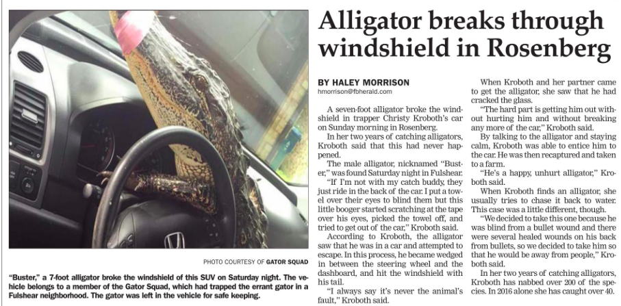
Even a blind alligator gets to eat sometimes.
1I know the strength of character and courage of Juanita Jean. One on one with the animal – my money is on JJ.
2Somebody’s gettin’ them some new boots!
3If Christy was a ‘good’ Texan, she would have left a loaded gun in her car, so Buster could have shot his way out of the vehicle. Indeed.
Arm the Alligators for a Better Texas!
4Awww, lil gator is just wantin’ to get the Regatorcan Party Veep job.
5Well qualified. He’s got the right attitude, a driving ambition to swallow anything, prays/preys on and eats any weaker, smaller critters, craps prodigiously, snaps at anything moving, fairly vision-impaired, spends most of his time underwater, except when getting free solar handouts, short legs and fingers ( ‘n prolly his widdle eenzee reptilian ‘nads too), stinks like CC’s fat hiney, loose cannon tail is 100K times size of teensy brain, all mouth, no smarts…etc etc.
A perfect match for the ‘Snake-eyed One’, true Reptilacans.
PS:
Yet another MCS weather system sliding down from the Mexican mountains is now slamming into S. C. TX, from Beeville to Austin, and north.
It looks to be moving right on down I-10 and 290 eastbound, look out JJ and Houston area.
This has chingos of NOAA official weather warnings springing up about everything imaginable, floods, very heavy rain, winds, hail, you name it (no snow tho, dang it, it’s so hot and humid you need gills).
http://radar.weather.gov/radar_lite.php?rid=ewx&product=N0Z&loop=yes
http://weather.unisys.com/radar/hires_rad.php?image=rad&inv=0&t=l3®ion=sp
6The alligator is a messenger from beyond saying Julius and Ethel were framed. 🙂
7PSS:
Look out Houston and East Texas.
STORMRAINZILLA IS HEADING DUE EAST BETWEEN BELOW HWY 90, ON DOWN I-10, ABOVE HWY 290.
(oops on the caps, but I’ll leave them, this is a monster MCS)
This system is going to bump up every river it crosses like crazy. You think you’ve seen major flood stages so far, just hang. It is going to get much worse.
Unless weakens, and as it’s been clobbering me and the ex, it just got worse through about two hours, easing a bit now..
Saw on the 12 teevee news a film clip of a herd (~40hd) of cattle mired on a small high spot on the edge of a Houston area river (Brazos?). When this storm gets over there those poor critters are gone pau unless somebody rescues them.
It seems to taper off here, then hits back, lightning like TEOTW, buckets of rain, wind tolerable so far. This biblical flood chit nearly every dang day is getting mighty old. At least it cooled down.
8.
http://radar.weather.gov/radar_lite.php?rid=ewx&product=NCR&loop=yes
Make that storm breadth, N-S, roughly between US HWY 87 southern, to TX HWY 21, northern tip; around 125 miles wide. More TSRA above and below, but less intense and over dryer ground.
9This WX system is the biggest thing going on in the cont US, lots bigger than Bonnie was/is on the ECoast.
.
http://weather.unisys.com/satellite/sat_sfc.php?inv=0&t=cur
10Good luck to everybody getting stormed on again. I had to look up what an MCS is; they don’t talk about them here in Maryland, though we do get the odd tornado, derecho, or hurricane.
And good luck to that poor gator– at least he (?) finally found a decent human being who wasn’t using him for target practice. I hope those who did shoot themselves firmly in the nadgers.
11That pink tape the lady gator hunter uses is a nice touch. Kinda classy! Might even start a trend! My late husband and his 2 brothers use to go out in a damn pirogue and hunt gators in the bayou. They were actually successful but their daddy insisted that they do their own skinning and drying. By the way, there was a 15 footer on a golf course in South Carolina today. It sure broke up a lot of foursomes as they headed for the 19th hole in a helluva hurry.
12Best wishes to all of you and your mandatory swimming lessons.
13Rhea,
Judging from the Unisys link I just gave, this puppy could be an MCC, bigger than an MCS. It looks bigger than Ohio to me.
Trust me, a serious WXnut, our weather here in South TX, since January, has been absolutely frikken stark ravin’ crazeee.
Pics of hail bigger than #6 ringpick grapefruits…
My rain gauge total since last October reads almost 60 inches, a normal full year’s average rainfall per NOAA’s records the last 150 years is about 24-29 inches here, semi-arid to arid country. The last 5-6 drought years were less than that.
Y’all remember a few years ago when much of TX was ablaze from the extended drought.
Bastrop, on the very flooded Colorado, was ground zero for one of the worst wildfires; now the floods come, Brenham floods of a couple of days ago are just East of Bastrop.
And the hurricane season is just starting. Those boogers can drop 10-48 inches of rain.
Yeehaa, it’s still flashin’ ‘n booming and raining here.
http://forecast.weather.gov/glossary.php?word=MCC
“MCC
Mesoscale Convective Complex. A large MCS, generally round or oval-shaped, which normally reaches peak intensity at night. The formal definition includes specific minimum criteria for size, duration, and eccentricity (i.e., “roundness”), based on the cloud shield as seen on infrared satellite photographs:
•Size: Area of cloud top -32 degrees C or less: 100,000 square kilometers or more (slightly smaller than the state of Ohio), and area of cloud top -52 degrees C or less: 50,000 square kilometers or more
•Duration: Size criteria must be met for at least 6 hours
•Eccentricity: Minor/major axis at least 0.7
MCCs typically form during the afternoon and evening in the form of several isolated thunderstorms, during which time the potential for severe weather is greatest. During peak intensity, the primary threat shifts toward heavy rain and flooding.”
14Hoellee Carp!
Now a Tornado Warning has popped up for NW of Beeville!
And remember, this MCC system is moving towards Houston.
http://www.srh.noaa.gov/crp/?mystation=KNGP
http://forecast.weather.gov/wwamap/wwatxtget.php?cwa=crp&wwa=tornado warning
“TORNADO WARNING
TXC025-312330-
/O.NEW.KCRP.TO.W.0012.160531T2302Z-160531T2330Z/
BULLETIN – EAS ACTIVATION REQUESTED
TORNADO WARNING
NATIONAL WEATHER SERVICE CORPUS CHRISTI TX
602 PM CDT TUE MAY 31 2016
THE NATIONAL WEATHER SERVICE IN CORPUS CHRISTI HAS ISSUED A
* TORNADO WARNING FOR…
NORTHERN BEE COUNTY IN SOUTHERN TEXAS…
* UNTIL 630 PM CDT
* AT 601 PM CDT…A SEVERE THUNDERSTORM CAPABLE OF PRODUCING A TORNADO
WAS LOCATED OVER PAWNEE…OR 13 MILES SOUTHWEST OF KENEDY…MOVING
EAST AT 20 MPH.
HAZARD…TORNADO AND HALF DOLLAR SIZE HAIL.
SOURCE…RADAR INDICATED ROTATION.
IMPACT…FLYING DEBRIS WILL BE DANGEROUS TO THOSE CAUGHT WITHOUT
SHELTER. MOBILE HOMES WILL BE DAMAGED OR DESTROYED.
DAMAGE TO ROOFS…WINDOWS…AND VEHICLES WILL OCCUR. TREE
DAMAGE IS LIKELY.
* THIS DANGEROUS STORM WILL BE NEAR…
MINERAL AROUND 620 PM CDT.
TULSITA…PETTUS…TULETA AND NORMANNA AROUND 630 PM CDT.
PRECAUTIONARY/PREPAREDNESS ACTIONS…
TAKE COVER NOW! MOVE TO A BASEMENT OR AN INTERIOR ROOM ON THE LOWEST
FLOOR OF A STURDY BUILDING. AVOID WINDOWS. IF YOU ARE OUTDOORS…IN A
MOBILE HOME…OR IN A VEHICLE…MOVE TO THE CLOSEST SUBSTANTIAL SHELTER
AND PROTECT YOURSELF FROM FLYING DEBRIS.
&&
LAT…LON 2871 9790 2870 9789 2869 9786 2867 9782
2868 9779 2866 9776 2850 9775 2843 9795
2868 9803 2872 9792
TIME…MOT…LOC 2301Z 275DEG 15KT 2865 9797
TORNADO…RADAR INDICATED
HAIL…1.25IN
$$
TMT
SEVERE WEATHER STATEMENT
NATIONAL WEATHER SERVICE CORPUS CHRISTI TX
554 PM CDT TUE MAY 31 2016
TXC025-297-312315-
/O.CON.KCRP.TO.W.0011.000000T0000Z-160531T2315Z/
LIVE OAK TX-BEE TX-
554 PM CDT TUE MAY 31 2016
…A TORNADO WARNING REMAINS IN EFFECT UNTIL 615 PM CDT FOR
NORTHWESTERN LIVE OAK AND NORTHWESTERN BEE COUNTIES…
AT 553 PM CDT…A SEVERE THUNDERSTORM CAPABLE OF PRODUCING A TORNADO
WAS LOCATED OVER PAWNEE…OR 15 MILES SOUTHWEST OF KENEDY…MOVING
SOUTHEAST AT 30 MPH. THE ROTATION WITH THE STORM NORTHWEST OF THREE
RIVERS APPEARS TO HAVE WEAKENED.
HAZARD…TORNADO AND HALF DOLLAR SIZE HAIL.
SOURCE…RADAR INDICATED ROTATION.
IMPACT…FLYING DEBRIS WILL BE DANGEROUS TO THOSE CAUGHT WITHOUT
SHELTER. MOBILE HOMES WILL BE DAMAGED OR DESTROYED. DAMAGE
TO ROOFS…WINDOWS…AND VEHICLES WILL OCCUR. TREE DAMAGE IS
LIKELY.
THIS DANGEROUS STORM WILL BE NEAR…
MINERAL AROUND 615 PM CDT.
PRECAUTIONARY/PREPAREDNESS ACTIONS…
TAKE COVER NOW! MOVE TO A BASEMENT OR AN INTERIOR ROOM ON THE LOWEST
FLOOR OF A STURDY BUILDING. AVOID WINDOWS. IF YOU ARE OUTDOORS…IN A
MOBILE HOME…OR IN A VEHICLE…MOVE TO THE CLOSEST SUBSTANTIAL SHELTER
AND PROTECT YOURSELF FROM FLYING DEBRIS.
&&
LAT…LON 2852 9781 2826 9826 2851 9833 2854 9833
2871 9808
TIME…MOT…LOC 2253Z 295DEG 24KT 2865 9802
TORNADO…RADAR INDICATED
HAIL…1.25IN
$$
TMT
15“
Probable tornado heading for Kingsville (King Ranch HQ, mansions).
16Tornado near Beeville still active.
Yikes.
Gumbo umm, gator gumbo.
17Hope everybody stays safe.
18It even looks like a 125 mile tall dragon now approaching HGX.
http://radar.weather.gov/radar.php?rid=hgx&product=N0R&overlay=11101111&loop=no
http://www.srh.noaa.gov/hgx/
19Stay safe however you can.
20God bless.
I used to drive 150 miles from my home in CA to Reno, NV, just to go to a restaurant that served something called “Gator Bites”; yum!
If you eat them first, they’re delicious!
21Sandridge, you said “Awww, lil gator is just wantin’ to get the Regatorcan Party Veep job.”
And then you described Ted Cruz.
22Howdy from earthquake country! (not the Oklahoma fracking kind, but the hang-onto-your-butt-the-San-Andreas-is-long-overdue-for-an-8.0 kind and give us here in the mountains ocean-front property). I could be a smart ass and ask you to ship some of that water to California, but I won’t. Having been reared on the Ohio River back in the days when Jeezus rode dinosaurs so I’ve known floods, then moved to Georgia where I got more intimately familiar with tornaders (we stood on the roof of the student union at UGA and watched 4 of them converge on Athens, then,, because we were police recruits, had to go help clean-up the aftermath) so I have great empathy for my Texas brothers and sisters.
I hope all y’all remain safe, dry and have no gators in your future, unless they are of the Tim Tebow/SEC blue and orange Florida genus, in which case you are my sworn mortal enemy of the football kind.
JJ, I may be coming to a town near you in August (yep, I decided I need to experience hell before I die, so I have a basis for comparison) and if I can shake loose from the seminar we’re conducting for the TPCA, I’ll find my way to your beauty salon. I lost your email in one of my routine equipment malfunctions or I’d be contacting you that way, so send it to me again, if you feel so inclined, so I can write it down on actual paper in the notebook I now keep for crap I do not want to lose.
XOXO
23“Alligators and me have us a deal. I don’t eat them; they don’t eat me. So far, so good.”
that certainly sounds like good deal to me.
24FTR,
31 May, Report on the Kingsville tornado and other WX events:
http://www.srh.noaa.gov/crp/?n=klebergcountytornado
They don’t happen down this way very often.
25