Catastrophic Life Threatening
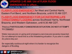
First time ever here, the NWS has issued a “Flash Flood Emergency for Catastrophic Life Threatening Flooding.” The freeways are mostly underwater. Thousands of homes are underwater. The fire department and volunteers are actually running out of fuel performing water rescues. The Coast Guard has announced it’s already performed 300 rescues. The KHOU television station has flooded.
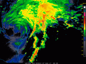
The center of Harvey is just sitting on top of Victoria, which puts Houston right in the path of giant rain bands flowing continuously out of the Gulf dumping tons of rain on the city. The NWS is forecasting this continuous rain for at least the next two days. Water is rising everywhere, all bayous are out of their banks, the Brazos and San Bernard are at flood stage.
The situation in Houston is, in a word, grim. Here comes another rain band. Gotta go for now.
it is amazing – prayers all around
1Please, please stay safe.
2Praying for you and all others dealing with flooding issues. Staying home from church myself just in case my very minor water-seeping-into-house issues from past years reoccur. Y’all’s issues are so much worse by a significant magnitude! Be safe!
3Please stay safe, one and all.
4Saying prayers for all.
5Checking in from Missouri City. East side of Quail Valley still dry. Streets flood then go down. We’ve still got power. Good luck and prayers for all. Stay safe.
6Good luck y’all.
The still well organized center of TS Harvey is just 0.6 degrees of longitude to the east of me, not “sitting on top of Victoria” (wish y’all would be a bit more accurate around here, see latest NOAA status below).
Conditions aren’t, nor have been, as bad here as in the Galveston/Houston/College Station areas as far as rainfall, but the wind is still howling and there is moderate rainfall in the periodic rainbands.
As some of us predicted, into it’s third day on land, Harvey is still one honkin’ SOB mofo, and will be around for possibly the rest of this week (ponder that a bit, like, this has just begun…).
Some models are taking Harvey back down to the coast. My SWAG: unlandfalling near Port O’Connor to Port Lavaca, then possibly going out a ways offshore, building up strength (maybe even to a reformed hurricane level), then coming back and landfalling at Freeport/Galveston and Houston (this would actually be Harvey’s fourth landfall, but I won’t get into the technicalities).
I hate to be the harbinger of bad news, but I’m a stone cold realist, and think y’all should know the facts as they are best defined.
Harvey has been, and still has the future potential, to be one of the most devastating hurricanes ever.
Son of a beach, this cyclone is a monster, am positive that the name Harvey will be removed from the NHC “names list”.
.
Tropical Storm HARVEY Public Advisory from the taxpayer paid for National Hurricane Center
(selected text, link to Harvey storm archive w/all reports):
http://www.nhc.noaa.gov/archive/2017/HARVEY.shtml?
BULLETIN
Tropical Storm Harvey Advisory Number 29
NWS National Hurricane Center Miami FL AL092017
1000 AM CDT Sun Aug 27 2017
SUMMARY OF 1000 AM CDT…1500 UTC…INFORMATION
7———————————————–
LOCATION…29.0N 97.4W
ABOUT 35 MI…55 KM WNW OF VICTORIA TEXAS
ABOUT 70 MI…115 KM ESE OF SAN ANTONIO TEXAS
MAXIMUM SUSTAINED WINDS…40 MPH…65 KM/H
PRESENT MOVEMENT…SSE OR 160 DEGREES AT 2 MPH…4 KM/H
MINIMUM CENTRAL PRESSURE…1000 MB…29.53 INCHES
DISCUSSION AND 48-HOUR OUTLOOK
——————————
At 1000 AM CDT (1500 UTC), the center of Tropical Storm Harvey was located near latitude 29.0 North, longitude 97.4 West. Harvey is moving toward the south-southeast near 2 mph (4 km/h), and a slow southeastward to east-southeastward motion is expected over the next couple of days. On the forecast track, the center will move very near the coast of southeastern Texas.
Maximum sustained winds are near 40 mph (65 km/h) with higher gusts. Little change in strength is forecast during the next 48 hours.
Tropical-storm-force winds extend outward up to 175 miles (280 km) primarily over water to the east and northeast of the center.
The estimated minimum central pressure is 1000 mb (29.53 inches).
Has the Drumpf administration blamed Harvey on Obama yet?
8Up here in Woodland Heights (just a wee bit North west of downtown Houston) the rain has barely let up and is now pouring again. While I am still high and dry – the news around the neighborhood is that streets that have NEVER flooded are seeing rising water. White Oaks Bayou is at a historic high – will send photos once the rain subsides.
Keep getting Tornado warnings but my pups haven’t set up the alarm yet (dogs know when sh#$t is going to happen)
Stay safe all.
9Gopher wood and pitch. Lots of it. 100 cubits long, 50 wide, 30 high.
10Joining in the prayers. Stay safe, y’all.
11Just heard a reporter refer to Harvey as a Perfect Storm. I think the media should start using terminology closer to Sandridge’s.
12Sharon G, my brother lives near White Oaks Bayou and just got back from walking over to take a peek. He has lived in Houston all his life and he’s never seen it like this.
13I’ve never been to Texas, but on a map the Brazos River meanders all over, which looks like pretty flat ground, and JJ’s town of Richmond is nearly encircled by a loop of the river. I’m hoping that the town doesn’t get cut off or flooded out, but I know a lot of other people are being flooded anyway. Our hearts are with you, and hoping for a good front to blow this rainmaker back out to sea.
14slipstream: I think you can pick up one of those gopher wood sailing vessels pretty cheap in Kentucky.
15Rhea, the town was settled in 1823 by and Stephen F. Austin and 300 families he brought here with land grants. Some of the families still live here. And yes, part of our town is surrounded on three sides by water. The lower part of that is reserved for parks, hiking, and pasture land because it does flood. It is being evacuated now. The river won’t crest until late Wednesday or Thursday.
16Here is one of the better views of the overall extent of this storm showing Harvey’s extent, the WFO HGX WSR-88D Long Range radar loop:
https://radar.weather.gov/ridge/radar_lite.php?rid=hgx&product=N0Z&loop=yes
Just refresh it every so often (you can also “save image” it on your computer as it’s a gif file).
Y’all landlubbers seldom appreciate the raw power of such natural forces.
Just think of Harvey, on it’s third day, still maintaining a “well organized” cyclonic circulation, while having been over land most of the time!
Convecting millions upon millions of TONS of water picked up from the GOM and transported, via strong winds hundreds of miles, and dumping that water on thousands of square miles. Doing this humongous convection around an eye, in a area that stretches from San Antonio to Waco to New Orleans, LA, to far out in the Gulf. It boggles the mind.
Harvey is an extreme weather event, and, despite the “deniers” (many of whom are in Houston, API anybody?), such events have been predicted, and to increase in the future.
17