The Sound You Hear Is Me Banging My Head Against the Kitchen Table

September 01, 2017 By: Juanita Jean Herownself Category: Uncategorized

Okay, here’s the deal.  There’s a mess of stuff on my mind this morning, so here goes.

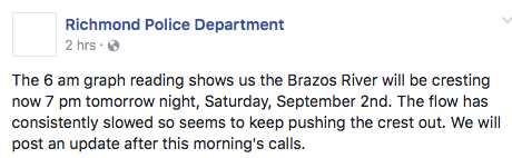
Remember how I told you that the Brazos River was going to crest on Wednesday morning and that’s when I’d know if I was going to flood or not?  Then it became Thursday afternoon, then early Friday morning.  I was too tired to wait it out so when my feet hit a dry floor this morning, I started singing the Hallelujah Chorus using my bedside table as drums.  Scared the crap outta Bubba, who assumed I was in labor or something.

Then I checked the local police department to see how high the river got when it crested.

Damn.

The river, they are saying, now won’t crest until …


So, the way I see it, this is Texas so we are bound to have a drought before the river crests so I’m just holding out for it.

And we are up to our necks in water but it doesn’t matter much because you can’t breathe the air above the water.


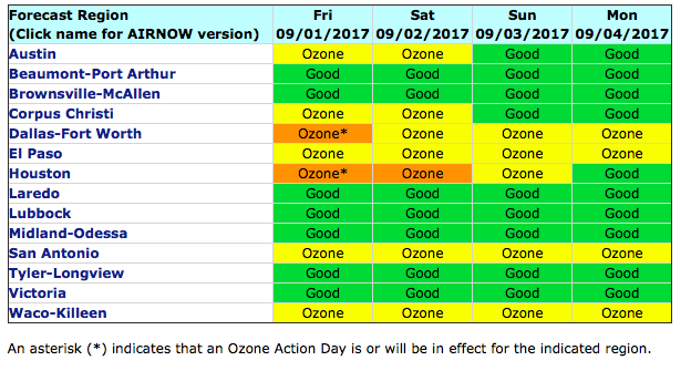
Yes, Houston is having an Ozone Action Day.  That means we have both hell and high water.

And there is no climate change.  None.  All this is just because we are heathens and need more prayer.  How do I know that? Because the Texas Secretary of State – who is appointed by the Governor – says so.

Quebec’s Minister of International Relations Christine St-Pierre called [Secretary of State Rolando] Pablos  to express her sorrow and condolences on behalf of the people of the Canadian province. She also offered equipment and manpower.

Pablos turned it down. Instead he asked for “prayers from the people of Quebec,” the minister relayed.

Look, Rolando, you damn fool, that was an answered prayer.

Thanks to everybody for the heads up.  

Be social and share!

0 Comments to “The Sound You Hear Is Me Banging My Head Against the Kitchen Table”


  1. Morning JJ. Earlier, when we stopped cleaning up long enough to eat breakfast, we were watching CNN. In an interview, the head of the national guard said he knew of no time in history when a tropical storm became a cat 4 hurricane in 2 days. A little later a weather man said Irma was a tropical storm yesterday, and this morning it’s a cat 2. Nothing to suggest that climate change is influencing weather there. No siree. I guess we’re gonna need even atheists and agnostics to quit lolligagging and start pulling their (our) weight in the praying department.

    1
  2. Would someone please splain to me how one can be an adult Hispanic in Texas and be a Republican? Are you deaf, blind, and crazy?

    2
  3. Hey Miss Juanita, according to the Pecan Grove MUD, the river crested this morning at 55.19′. It would appear that things are finally getting better!

    3
  4. Jane & PKM says:

    Micr, it’s a rare mental defect not limited to Texas. Evidence the Idi Amin look alike former county Sheriff Clarke of WI. Or, the Log Cabin snacilbupeR. Or, those Dolt45 voters who vote snacilbupeR against their own economic interests.

    Oops. Did I say rare? Strike that.

    4
  5. Juanita Jean Herownself says:

    Thank you, Jill Ann. Did you hear that they are having to shut down parts of the River Bridge on 59?

    5
  6. Surprised nobody yet has cited the joke(?) about the guy on his roof who turns down the helicopter and the boat because he’s praying to God for rescue, and God finally tells him that he sent the chopper and the boat, you damn fool. (I paraphrase.)

    I thought Texas was one of the higher prayers-per-capita states and you’re still getting dumped on, so this atheist’s “prayers” aren’t really going to help. It’s probably Mother Nature’s retribution for most of y’all electing such dumbass climate-change deniers. Gods have bad aim, so it landed mostly on a blue city instead of those red idiots.

    6
  7. Those damned hypocritical godbotherers and biblethumpers irritate the chit outta me at any time.

    Moving on to the factual world of reality:
    Here is a very abbreviated Hurricane Harvey NHC Bulletin abstract. I have chosen just a –few– of them (RLY, HTFG), to show significant breakpoints in this long, terrible storm (I really do follow the WX closely).
    Edited them severely, removed the CF/LF’s as best I could to compact the lines. This isn’t easy on a gdmnd 100Kbps internet conn (thkuvrymch, telcos and TX politicians).

    Each Bulletin is separated by a line of “]]]]]]]]]]]]]]” by me for readability.
    A simple text enhancement function (bold, italics, etc) would probably help here at TWMDBS.

    On Thu 1000AM, Harvey was a strong TS (had been for some time as it moved along in the GOM).
    Upgraded to a Cat 1 Hurricane at Thu 1200PM.
    Upgraded to a Cat 2 Hurricane at 1200AM Fri.
    Called a “Major Hurricane” at 400PM Fri, means it was now a Cat 3.
    (Note: NHC considers a major hurricane a Cat 3 and above, Cats 1&2 are not “major”.)
    Upgraded just before landfall to a Cat 4, at 6PM Fri. It bullseye clobbered the Rockport, TX area for hours.
    Downgraded to a Cat 3 at 0200AM Sat, and later further downgraded throughout Sat.

    Link to the whole NHC Hurricane Harvey archive, text and graphics, from 20170817 to 20170831:
    http://www.nhc.noaa.gov/archive/2017/HARVEY.shtml?

    ZCZC MIATCPAT4 ALL
    TTAA00 KNHC DDHH
    BULLETIN
    Tropical Storm Harvey Advisory Number 16
    NWS National Hurricane Center Miami FL AL092017
    1000 AM CDT Thu Aug 24 2017
    …HARVEY QUICKLY STRENGTHENING AND FORECAST TO BE A MAJOR HURRICANE WHEN IT APPROACHES THE MIDDLE TEXAS COAST…
    …LIFE-THREATENING STORM SURGE AND FRESHWATER FLOODING EXPECTED…
    SUMMARY OF 1000 AM CDT…1500 UTC…INFORMATION
    ———————————————–
    LOCATION…24.0N 93.3W
    ABOUT 365 MI…590 KM SE OF CORPUS CHRISTI TEXAS
    ]]]]]]]]]]]]]]]]]]]]]]]]]]]]]]]
    Hurricane Harvey Tropical Cyclone Update
    NWS National Hurricane Center Miami FL AL092017
    1200 PM CDT Thu Aug 24 2017
    …HARVEY STRENGTHENS TO A HURRICANE WITH 80-MPH WINDS…
    Data from an Air Force Reserve Hurricane Hunter aircraft indicate that Harvey has intensified to a hurricane, with maximum sustained winds of 80 mph (130 km/h).
    A Special Advisory will be issued by 1 PM CDT (1800 UTC) in lieu
    of the intermediate advisory to update the intensity forecast.
    SUMMARY OF 1200 PM CDT…1700 UTC…INFORMATION
    ———————————————-
    LOCATION…24.3N 93.5W
    ABOUT 340 MI…550 KM SE OF CORPUS CHRISTI TEXAS
    ]]]]]]]]]]]]]]]]]]]]]]]]
    BULLETIN
    Hurricane Harvey Special Advisory Number 17…CORRECTED
    NWS National Hurricane Center Miami FL AL092017
    100 PM CDT Thu Aug 24 2017
    ]]]]]]]]]]]]]]]]]]]]]]]]
    Hurricane Harvey Tropical Cyclone Update
    NWS National Hurricane Center Miami FL AL092017
    1200 AM CDT Fri Aug 25 2017
    …12 AM CDT POSITION ESTIMATE…
    …HARVEY STRENGTHENS TO A CATEGORY 2 HURRICANE…
    Recent data from a NOAA Hurricane Hunter aircraft indicate that Harvey has strengthened. The estimated maximum sustained winds have increased to near 100 mph (160 km/h).
    SUMMARY OF 1200 AM CDT…0500 UTC…INFORMATION
    ———————————————-
    LOCATION…25.5N 94.9W
    ABOUT 220 MI…355 KM SE OF CORPUS CHRISTI TEXAS
    ]]]]]]]]]]]]]]]]]]]]]]]]]]]]]]
    BULLETIN
    Hurricane Harvey Advisory Number 20
    NWS National Hurricane Center Miami FL AL092017
    400 AM CDT Fri Aug 25 2017
    …HURRICANE HARVEY DANGEROUSLY APPROACHING THE TEXAS COAST…
    SUMMARY OF 400 AM CDT…0900 UTC…INFORMATION
    ———————————————-
    LOCATION…25.9N 95.4W
    ABOUT 180 MI…290 KM SE OF CORPUS CHRISTI TEXAS
    ]]]]]]]]]]]]]]]]]]]]]]]]]]]]]]]]]]]]]]]]]]]]]]]]]]]]
    BULLETIN
    Hurricane Harvey Intermediate Advisory Number 21A
    NWS National Hurricane Center Miami FL AL092017
    100 PM CDT Fri Aug 25 2017
    …WEATHER CONDITIONS DETERIORATING AND WATER LEVELS RISING ALONG
    THE TEXAS COAST…
    ]]]]]]]]]]]]]]]]]]]]]]]]]]]]]]]]]]]]]]]]]]]]]]]]]]]]
    BULLETIN
    Hurricane Harvey Advisory Number 22
    NWS National Hurricane Center Miami FL AL092017
    400 PM CDT Fri Aug 25 2017
    …MAJOR HURRICANE HARVEY BEARING DOWN ON THE TEXAS COAST…
    …CATASTROPHIC FLOODING EXPECTED DUE TO HEAVY RAINFALL AND STORM SURGE…
    SUMMARY OF 400 PM CDT…2100 UTC…INFORMATION
    ———————————————-
    LOCATION…27.5N 96.5W
    ABOUT 60 MI…95 KM ESE OF CORPUS CHRISTI TEXAS
    ]]]]]]]]]]]]]]]]]]]]]]]]]
    Hurricane Harvey Tropical Cyclone Update
    NWS National Hurricane Center Miami FL AL092017
    500 PM CDT Fri Aug 25 2017
    …5 PM CDT POSITION AND INTENSITY UPDATE…
    …SUSTAINED HURRICANE-FORCE WINDS ABOUT TO MOVE ONSHORE…
    ]]]]]]]]]]]]]]]]]]]]]]]]]]]]]]]]]]]]]]]]]]]]]]]]]]
    Hurricane Harvey Tropical Cyclone Update
    NWS National Hurricane Center Miami FL AL092017
    600 PM CDT Fri Aug 25 2017
    …6 PM CDT POSITION AND INTENSITY UPDATE…
    …HARVEY BECOMES A CATEGORY FOUR HURRICANE… …SUSTAINED HURRICANE-FORCE WINDS SPREADING ONTO THE MIDDLE TEXAS
    COAST…
    Air Force Reserve Reconnaissance aircraft data indicate that Harvey has become a category 4 hurricane with maximum sustained winds of 130 mph (215 km/h).
    A station at Aransas Pass run by the Texas Coastal Observing Network recently reported a sustained wind of 74 mph (119 km/h) with a gust to 96 mph (154 km/h).
    SUMMARY OF 600 PM CDT…2300 UTC…INFORMATION
    ———————————————-
    LOCATION…27.7N 96.7W
    ABOUT 45 MI…70 KM E OF CORPUS CHRISTI TEXAS
    ABOUT 50 MI…85 KM SSW OF PORT OCONNOR TEXAS
    MAXIMUM SUSTAINED WINDS…130 MPH…215 KM/H
    PRESENT MOVEMENT…NW OR 325 DEGREES AT 8 MPH…13 KM/H
    MINIMUM CENTRAL PRESSURE…941 MB…27.79 INCHES
    ]]]]]]]]]]]]]]]]]]]]]]]]]]]]]]]]]]]]]]]]]]
    BULLETIN
    Hurricane Harvey Intermediate Advisory Number 22A
    NWS National Hurricane Center Miami FL AL092017
    700 PM CDT Fri Aug 25 2017
    …EYE OF CATEGORY 4 HARVEY APPROACHING THE COAST BETWEEN PORT ARANSAS AND PORT O’CONNOR TEXAS…
    …CATASTROPHIC FLOODING EXPECTED DUE TO HEAVY RAINFALL AND STORM SURGE…
    SUMMARY OF 700 PM CDT…0000 UTC…INFORMATION
    ———————————————-
    LOCATION…27.8N 96.8W
    ABOUT 35 MI…55 KM E OF CORPUS CHRISTI TEXAS
    ABOUT 50 MI…80 KM SSW OF PORT OCONNOR TEXAS
    ]]]]]]]]]]]]]]]]]]]]]]]]]]]]]
    Hurricane Harvey Tropical Cyclone Update
    NWS National Hurricane Center Miami FL AL092017
    800 PM CDT Fri Aug 25 2017
    …8 PM CDT POSITION AND INTENSITY UPDATE…
    …THE EYEWALL OF CATEGORY 4 HARVEY BEGINNING TO MOVE ONSHORE OF THE MIDDLE TEXAS COAST…
    A station at Aransas Pass run by the Texas Coastal Observing Network recently reported a sustained wind of 90 mph (145 km/h) with a gust to 108 mph (174 km/h).
    A station at Flour Bluff, Texas, recently reported a sustained wind of 81 mph (130 km/h).
    SUMMARY OF 800 PM CDT…0100 UTC…INFORMATION
    ———————————————-
    LOCATION…27.9N 96.8W
    ABOUT 35 MI…60 KM E OF CORPUS CHRISTI TEXAS
    ABOUT 40 MI…70 KM SW OF PORT OCONNOR TEXAS
    MAXIMUM SUSTAINED WINDS…130 MPH…215 KM/H
    PRESENT MOVEMENT…NW OR 325 DEGREES AT 8 MPH…13 KM/H
    MINIMUM CENTRAL PRESSURE…941 MB…27.79 INCHES
    ]]]]]]]]]]]]]]]]]]]]]]]]]]]]]]]]]]]]]]]]]]]]]]]
    Hurricane Harvey Tropical Cyclone Update
    NWS National Hurricane Center Miami FL AL092017
    900 PM CDT Fri Aug 25 2017
    …9 PM CDT POSITION AND INTENSITY UPDATE…
    …EYE OF CATEGORY 4 HARVEY ALMOST ONSHORE…
    ]]]]]]]]]]]]]]]]]]]]]]]]]]]]]]
    BULLETIN
    Hurricane Harvey Advisory Number 23
    NWS National Hurricane Center Miami FL AL092017
    1000 PM CDT Fri Aug 25 2017
    …EYE OF CATEGORY 4 HARVEY MAKES LANDFALL BETWEEN PORT ARANSAS AND
    PORT O’CONNOR TEXAS…
    …CATASTROPHIC FLOODING EXPECTED DUE TO HEAVY RAINFALL AND STORM SURGE…
    ]]]]]]]]]]]]]]]]]]]]]]]]]]]]
    Hurricane Harvey Tropical Cyclone Update
    NWS National Hurricane Center Miami FL AL092017
    1100 PM CDT Fri Aug 25 2017
    …11 PM CDT POSITION UPDATE…
    …EYE OF CATEGORY 4 HARVEY NOW OVER ARANSAS BAY TEXAS…
    ]]]]]]]]]]]]]]]]]]]]]]]]]]]]]]]
    Hurricane Harvey Tropical Cyclone Update
    NWS National Hurricane Center Miami FL AL092017
    1200 AM CDT Sat Aug 26 2017
    …12 AM CDT POSITION UPDATE…
    …DANGEROUS HARVEY NEAR THE MOUTH OF COPANO BAY…
    ]]]]]]]]]]]]]]]]]]]]]]]]]]]]]]]]]]]]]]]]]]]]]]]]]]]]
    BULLETIN
    Hurricane Harvey Intermediate Advisory Number 23A
    NWS National Hurricane Center Miami FL AL092017
    100 AM CDT Sat Aug 26 2017
    …HARVEY MAKES A SECOND LANDFALL ON THE NORTHEASTERN SHORE OF COPANO BAY…
    SUMMARY OF 100 AM CDT…0600 UTC…INFORMATION
    ———————————————-
    LOCATION…28.2N 97.0W
    ABOUT 5 MI…10 KM N OF ROCKPORT TEXAS
    ABOUT 45 MI…75 KM S OF VICTORIA TEXAS
    ]]]]]]]]]]]]]]]]]]]]
    BULLETIN
    Hurricane Harvey Intermediate Advisory Number 23A
    NWS National Hurricane Center Miami FL AL092017
    100 AM CDT Sat Aug 26 2017
    …HARVEY MAKES A SECOND LANDFALL ON THE NORTHEASTERN SHORE OF COPANO BAY…
    SUMMARY OF 100 AM CDT…0600 UTC…INFORMATION
    ———————————————-
    LOCATION…28.2N 97.0W
    ABOUT 5 MI…10 KM N OF ROCKPORT TEXAS
    ABOUT 45 MI…75 KM S OF VICTORIA TEXAS

    7
  8. Rhea: “…bad aim, so it landed mostly on a blue city instead of those red idiots.”

    Rhea, the bullseye of Harvey landed on little Aransas County (my 2nd home) and the surrounding ones. They voted better than 70% for tRump and Blake (PajamaBoy) Farenthold.

    There are many working class people there (significant Hispanic pop), a lot of retirees (many low income), and some pretty wealthy ones too. Many mobile homes too, lots of people live in small “park models” (I once had one in Port Isabel for the HobieCat) and travel trailers; many cannot be moved.
    The area is known as the “Texas Redneck Riviera”. Those fools will continue to vote against their own interests until they croak, no matter what happens.
    The upscale Rockport area of Key Allegro got slammed (artificial fill ‘fingers’ w/canals- all waterfront lots, check a map), lots of upscale second-home beach houses owned by ppl from Dallas/Austin/SA/Hou/etc. At the Key Allegro Marina on Little Bay, many boats were all smooshed together.
    Watch where the gubmint relief money goes…

    8
  9. And now Irma is a cat 3. Pray harder everybody. If the non-believers would just forget all that fake science and start praying, we could lower the ocean temperatures several degrees. Hell, governor good hair’s Texas stadium prayer meeting finally worked. So now that the Orange Messiah has anointed him to the cabinet, he oughta have some serious theocratic firepower. But I don’t think I’ve got his new number. Damn.I’m gonna loose track of all the things I gotta pray for.

    9
  10. Prup (aka Jim Benton) says:

    Just heard (CNN) they have tested the water and it has incredible levels of E. Coli and coliform bacteria. There are even signs of flesh-eating (possible, not confirmed).

    Be careful on a level you aren’t used to. We Can’t br losing any of you folk.

    10
  11. WA Skeptic says:

    “Incredible levels of E. Coli and coli form bacteria”–take hot water and hot air, mix with human sewage and unknown amounts of various hydrocarbons. Result: Toxic Soup. MMMM–southern cookin’ at it’s worst.

    Poor Texas–plagued by no codes or business regulations and political corruption.

    11
  12. Well, it should be obvious to all of us by now. Harvey was God’s way of punishing us for electing Trump, Abbott, Patrick, and the rest of that bunch…

    12
  13. Friend of mine with Kentucky Civil Air Patrol is down there flying over and taking pictures. He was headed for the Bravos River Friday afternoon so I told him to wave at you and he says he did.

    13
  14. Juanita Jean Herownself says:

    Hey Yellow Dog, next time let me know and I’ll go out on the porch and wave back!

    14